
Jump to: About Mt. Ulap | How to Get There | Hike Highlights & Difficulty | Suggested Itinerary | Sample Budget | Where to Stay | Travel Tips | Final Thoughts
About Mt. Ulap
Mt. Ulap, located in Itogon, Benguet, is one of the most popular day hikes in Northern Luzon. Its name literally means “mountain of clouds,” and for good reason—its scenic trail passes through pine forests, ridges, and viewpoints often surrounded by a sea of clouds. The summit reaches about 1,846 meters above sea level and offers breathtaking views of Benguet's highlands and Cordillera peaks.
How to Get There
- From Manila: Take a bus to Baguio City (Victory Liner, Genesis, JoyBus; ₱500–₱600, ~4–6 hours)
- From Baguio: Ride a jeepney bound for Ampucao (₱40–₱50, ~45 minutes)
- Registration: Register at the Brgy. Hall in Ampucao and pay the environmental and guide fees
Looking for a convenient way to reach Benguet? Skip the long lines and secure the best travel deals instantly — book your bus, ferry, and train tickets with 12Go. Book your tickets through: https://12go.tpx.lv/28wx175m — the fastest, hassle-free platform for comparing routes, schedules, and prices in one place.
Hike Highlights & Difficulty
- ⛰️ Trail Difficulty: Moderate (3/9) – best for beginners with good fitness
- 🌲 Scenery: Pine forests, open ridges, rocky cliffs, and cloud-covered peaks
- 📸 Viewpoints: Gungal Rock, Ambanao Paoay, and the Mt. Ulap summit
- 🕒 Hike Duration: 4–6 hours (point-to-point)
Mt. Ulap Overnight Itinerary
Arrival in Baguio

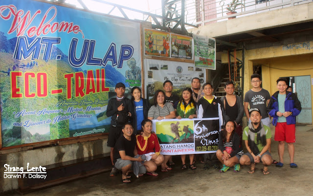
We arrived in Baguio City past eleven in the morning. We had our breakfast/lunch at Emil Rose Restaurant. The ambiance inside this restaurant is amazing; there is no air conditioner, but the temperature is cool, and the foods taste good and are served elegantly. After the sumptuous lunch, we continued traveling to Itogon, Benguet. From Baguio to Itogon is more than an hour of travel, but it was a bit challenging because of the bad weather. The rain and the wind were strong, and the roads were covered with fog, making zero visibility. It was past one in the afternoon when we arrived at the covered basketball court. Took a short break and processed the registration and guides.
The Jump Off
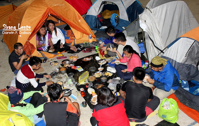
The management did not authorize us to continue a day hike on Mt. Ulap because of the bad weather conditions. Instead, we set up a camp at the covered court, other groups followed, and we started preparing our dinner. After dinner, we had our socials and rested at around two in the morning. Three-quarters of the basketball court is covered, but the temperature is really cold.

Start of Hike
The Start of Our Hike: Woke up at five in the morning and prepared coffee, noodles, and bread with cheese for our breakfast. While having our Breakcamp, five familiar faces arrived, including our very own Iosif. The last time that we met Iosif was two years ago, during our Mount Mabilog hike, so it was a long, long chit-chat while we were also preparing for our ascend.

Walking on the Trails of Mt. Ulap
Seven in the morning—we left the court. The first part was walking on an ascending concrete road, then followed by trekking. The terrain is clean, with grass on the ground, pine trees, and gorgeous flowers. The trail is considered gradual, but our hike was a bit challenging because of the bad weather conditions. The trails are wet, muddy, and slippery. The surroundings are also covered with thick fog, making us not to witness its natural beauty. The photos below will describe how the bad weather conditions affected our hike.


Reached the Campsite
The area is wide and open but is still covered with thick fog; rock balancing was also created to add art to the background. We waited for a few minutes at Camp 1, hoping for the weather to settle, but no changes at all, so we continued our ascent. We can't change the weather, so we just enjoyed the surroundings. Good thing that I was with these good and noisy people. Hahaha.

Reached the Summit
It took us almost two hours from Camp 1 to Gongal or Camp 2. Upon arrival, hikers were having their photo ops on top of the boulders. The same scenario: the area is covered with thick fog, the wind is strong, and the raindrops are like blades slashing our skin because of its cold temperature. We stayed there for an hour and then, descent. We thought the weather would be fine, yet everything was the same. We were wearing raincoats, waterproof jackets, and umbrellas; those look good in photos, though.


At exactly noon, we reached the jump-off on the highway. The same bad weather conditions. We rested for an hour and broke camp. Tidy up and leave Itogon. Our next destination was Baguio City for our meryenda at Good Taste. We were all tired, but while on the road, everyone was energetic, especially when we talked about peanuts. May mga nahugasang peanuts, may dry na peanuts, may wet na peanuts, pero kahit kelan wala pa akong nakitang pa-horizontal na peanuts. This was Batang Hamog Mountaineers' 6th anniversary! I am happy to see these people again. Sabi ko nga: "Kahit hindi matuloy ang akyat sa Mount Ugo, basta kasama ko ang mga indibidwal na ito, masaya na ako at hinding-hindi ko pag-sisisihan. Hangang sa susunod!"
Sample Budget (per person)
- Manila to Baguio (RT): ₱1,000
- Baguio to Ampucao Jeepney (RT): ₱100
- Registration Fee: ₱100
- Environmental Fee: ₱30
- Guide Fee (₱600 / 5 pax): ₱120
- Snacks, water, packed lunch: ₱300
- Total: ₱1,650 – ₱1,800
Where to Stay
- 🏨 Baguio Options: Venus Parkview Hotel, Bed and Bath at Station 120, The Manor at Camp John Hay
🏨 Check affordable hotels in Baguio and get the best deals through: https://trip.tpx.lv/c5pY35fP
Travel Tips
- Wear layers – it can be cold early morning and windy at the summit
- Use trekking poles if you have knee issues
- Don’t skip Gungal Rock – one of the most iconic photo spots
- Be mindful of trash and practice Leave No Trace principles
- Pre-register with the tourism office if you’re going on a weekend or holiday
Final Thoughts
Mt. Ulap is one of the best beginner-friendly hikes in Luzon, offering breathtaking landscapes, fresh mountain air, and cultural insight. Whether you're a seasoned trekker or a first-time hiker, the sea of clouds and ridgeline views will leave you awe-inspired. It’s a perfect escape from city life and a reminder of how beautiful the Cordilleras truly are. Looking for travel ideas across the country? Read my complete guide to visiting all 82 provinces in the Philippines — based on my actual travels.
No comments:
Post a Comment
Enter Comment Below: