

Jump to: About Mt. Tabayoc | How to Get There | What to Expect | Suggested Itinerary | Travel Budget | Where to Stay | Travel Tips
About Mt. Tabayoc
Mt. Tabayoc is the second-highest mountain in the Philippines at 2,842 meters above sea level, located in Kabayan, Benguet. Known for its mossy forest, cold climate, and rich biodiversity, it is part of the Mt. Pulag National Park and sits beside the mystical Lake Tabeo. The hike is a combination of adventure and immersion in the Cordilleras’ untouched beauty.
How to Get to Mt. Tabayoc
- Jump-off Point: Lake Tabeo, Brgy. Ballay, Kabayan, Benguet
- From Baguio: Ride a bus or van to Kabayan (approx. 6–8 hours via Ambuklao or Halsema)
- 4x4 Option: Required to reach Lake Tabeo during rainy season or for group trips
- Registration: Coordinate with the Ballay Barangay Hall or DENR Kabayan for registration and guides
What to Expect at Mt. Tabayoc
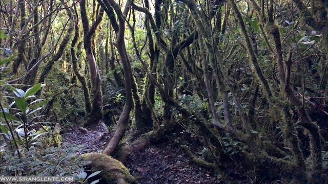
- 🌲 Dense mossy forest trail covered in fog and wild flora
- ❄️ Very cold temperatures, especially at night (as low as 5°C)
- 🧭 Technical but short trail (2–3 hours ascent, steep and narrow)
- 📷 Stunning views from the summit and mysterious Lake Tabeo
- ⛺ Campsites near Lake Tabeo and views of nearby Mt. Pulag
Suggested 2-Day Itinerary
Day 1: - Early departure from Baguio to Kabayan - Registration and orientation at Brgy. Hall - Camp at Lake Tabeo - Optional side trip to 4 Lakes (Tabeo, Ambulalakao, Incolos, Letepngepos) Day 2: - Early morning hike to Mt. Tabayoc summit - Descend, pack up, and travel back to Baguio
Our travel from Mt. Timbac to Tabayoc was a long journey - it's within four hours. So, after the relaxed hike on Timbac, next was sleeping while traveling. No lunch yet - pero busog naman ang mga mata namin sa napaka-gandang tanawin. Subalit, kahit anung hanap ko ng appreciation yung ganda, hindi parin maipasok sa isipan ko, ramdam ko parin ang gutom ko. Sabi ko nga: "Kahit gaano ka busog ang mata mo, di parin ito matatanggal ang pag-kalam ng sikmura mo, tama diba?" Infairness, masarap ang fresh carrots huh, para tuloy akong rabbit. It was a long, curve-y, uphill road. And at around 1600, we finally reached Ballay Ranger Station.

Ballay Ranger Station is at Tabayo, Ballay, Kabayan, Benguet. It was cold—I noticed that when I opened the door and went out of the van. Low temperatures in this area are normal because of its elevation, and it is still part of Mt. Pulag National Park. Since the sun was almost setting, upon arrival, we set up our camp, changed into cold-weather outfits, and prepared our dinner.
While the sun was waving goodbye, the bluish sky started changing its colour into gold. The sky set a perfect backdrop as it showcased a golden reflection on Lake Tabeo. It was already dark when we finished the dinner preparation. The next part was a sumptuous dinner with rice and a hot, creamy sinigang. After dinner, I rested while thinking, "I am not going to summit!"
Second Day: Te Bing woke me up by shouting, " Ang ganda ng mga stars, dali! Bumangon kana!" I hurriedly grabbed my DSLR and opened the tent door. Anndddd... okay... the stars were fine in the skies, but they weren't astounding because of the clouds blocking them. We prepared our cold and moisture-proof outfit and served hot coffee and bread as our super-light breakfast. Around 0200, we started ascending to the summit.

The photo above is the staircase that goes up to the view deck of Tabayoc. As expected, the challenging part of hiking Mt. Tabayoc is the steep and assault trails to the summit. Plus the very cold wind mixed with moisture - ay talaga namang may tutulong sipon sa ilong mo ng hindi mo namamalayan. In fairness, the ambience in the morning was relaxing, and I heard birds singing—the sssshhhh sound created when the wind blows. The trails have no access to moonlight, so a flashlight is required! Finally, I reached the summit at around 0530.


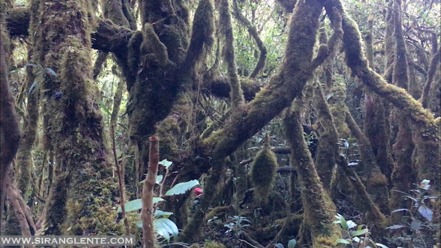
The summit has no open space; the management created an improvised view deck situated on top of the trees. Since it's improvised, it has a limited weight limit (it can only accommodate a maximum of 3-4, depending on your weight). While I was waiting for my turn to climb up to the view deck, the sunlight started penetrating the trail. When I saw the surroundings, I was stunned by its healthy forest; the mosses, ferns, and orchids were happily hanging on the branches. It was my turn; upon standing on the wooden viewing deck, I was mesmerised by what I saw. There's a 360-degree view, with Mt. Pulag in the background and its famous "sea of clouds."

We stayed on the view deck for about 20 minutes because another group had just arrived. Descending on a steep downhill trail was a bit challenging, but it is one of the most preserved virgin forests in the Philippines, so there's a rich bio-diversity of plants, such as the colorful flowers by the trail and orchids hanging on the trees—really pleasing to the eyes. The soprano voices of the birds singing added a more relaxing ambience. Syempre hindi ako papatalo sa mga birds, sinasabayan ko sila gamit ang mala Mariah Carrey ko na whistle.

Another view deck with Lake Tabeo in the background. The trails of Mt. Tabayoc are covered with trees, so the only access to view the surrounding villages and the beautiful terraces is the summit and the view deck (photo above). Posing at this spot wasn't easy because the only way to capture this photo was to walk on a horizontal tree trunk hanging on a cliff; this knee-shaking photo shoot was worth it! There's a clear view of Mt. Pulag, hiding on the white cottony clouds, and the terraces are just so artistic - I can personally compare this shot to the early civilisation of Machu Picchu in Peru, Google it!

Based on my camera timestamp, the descent is within two hours - this includes an unli picture on the trail. The only proof that you're by the lake is the farmlands - the trail doesn't have access to view the villages. Upon arrival by Lake Tabeo, the sun just showed its hot shine that stopped the cold ambience. At the camp, we had our breakfast part 2 and tidied up. Then, break camp. Hiking Mt. Tabayoc is highly recommended to those people who are searching for a virgin and mossy forest.

A group photo at Good Taste Restaurant, Baguio. I had a headache during our climb because of a lack of sleep, but I enjoyed it. The next part would be the long, winding journey to Baguio City for an eat-out. Travel Period: 3 hours and 30 minutes. In Baguio, we were surprised by the heavy traffic due to heavy rains. It's hard to find parking, so we decided to have a break at Good Taste Restaurant.
Travel Budget (per person, group of 4)
- Transportation (RT Baguio–Kabayan): ₱600–₱800
- Registration Fee: ₱150
- Guide Fee: ₱1,200 per group (₱300/head if shared)
- Food & Supplies: ₱500
- Camping Fee (Lake Tabeo): ₱100
- Total (Estimated): ₱1,600–₱2,000+
Where to Stay
- Camping: Designated campsites near Lake Tabeo
- Basic Homestays: Available in Ballay or Kabayan Poblacion
- Alternative: Stay in Baguio before or after the climb
🏨 Book Baguio accommodations via Agoda
Travel Tips
- Bring thick clothing — temperatures drop dramatically at night
- Always trek with a guide due to unclear and mossy trails
- Bring headlamps, water filters, and trail snacks
- Practice Leave No Trace and respect local communities
Final Thoughts
Mt. Tabayoc offers an off-the-beaten-path climb that rewards hikers with mystical forests, peaceful lakes, and cool mountain air. It’s an ideal destination for mountaineers seeking solitude, biodiversity, and a break from more commercialized trails like Mt. Pulag. As someone who has visited all 82 provinces in the Philippines, I’ve created a complete guide to help you explore each one. Check out my Philippines 82 Provinces Travel Guide here.

Enchanted forest vibes — the trail to Mt. Tabayoc, Benguet
Also read: Hiking Mt. Pulag – Highest Mountain in Luzon