

Introduction:
Mount Hamiguitan is one of the most beautiful mountains in the Philippines because it is the home of thousands of flora and fauna. Some are endemic or can only be found on the terrains of this mountain. Not just the richness of its bio-diversity, its mountain range showcases the spectacular and breathtaking natural beauty at its finest. Because of that, it was declared as a sanctuary by virtue of R.A. 9303. With its natural wonders, it was also included as one of the ASEAN Heritage Parks. In 2014, this mountain was added to the UNESCO List of World Heritage Sites.

Important Details About Mt. Hamiguitan:
- Location: Davao Oriental
- Coordinates: 6°44′24″N 126°10′54″E / 6.74000°N 126.18167°E
- Height/Elevation: 1,620 MASL
- Hiking Difficulty: 6/9
- Trails Class: 3 with a river crossing
Day 0 - Hike Itinerary
- Orientation at DENR Office.
- Strictly No Walk-in Trekkers. For booking and reservations, contact Cylle Marie S. Nadonza, PA Conservation Officer, on Ph: 09502732498 or Clint Michael B. Cleofe, Ecosystems Mgt. Specialist, on Ph: 09367053518 (these contacts are from the brochures issued during our hike).
- Only 30 trekkers are allowed in every trekking duration of 3 days on campsites, excluding the eco guides and porters.
- Regular trekking Fee: 3,000 Pesos, inclusive of Trekkers ID, Trekkers Orientation and Certificate of Climb.
- Other Fees: DSLR Camera: 500 pesos per camera. Drone Camera: 1,000 pesos per camera.
- Fees might change without prior notice.
Day 1 - Hike Itinerary
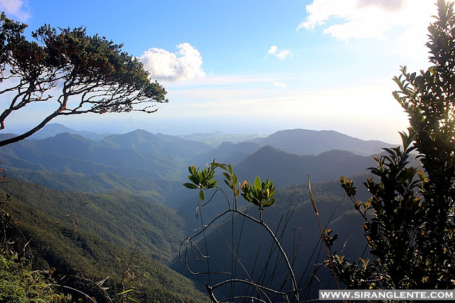
We started trekking Mt. Hamiguitan at 8AM, and our goal for Day 1 was to reach Camp 3, the area provisioned for an overnight camp for trekkers. Though Pinoy Mountaineer listed this mountain with a difficulty of 6/9 and a trail class of 3 with a river crossing, I categorically consider it as one of those 8/9 mountains. The trails are well established, and the markers are visible. It has a mix of easy, moderate, and hard types, such as the assault after the "Uwang-Uwang" creek and falls.
What to Expect: Crossing the free-flowing crystal clear and cool waters of "Puting Bato." Then, while the cool breeze was blowing, we had our lunch at the Lantawan Uno (908 MASL), with the perfect view of the ranges. Also, on this site, one of the endemic types of pitcher plants can be found. Next, crossing the "Uwang-Uwang" creek and falls (997 MASL) followed by the unforgettable assault. Followed by the challenging "Bika-Bika" trail to the campsite. At 3PM, we arrived at the Camp 3 (1,151 MASL).

 |
| Photo taken at Bika-Bika Trail. |
 |
| A photo of a Philippine Ground Orchid. |
 |
| Photo: The campsite of Mt. Hamiguitan. |
 |
| A photo of the Black Mountain. |
The view at the Black Mountain (1,193 MASL). After setting up the camp, we headed to the Black Mountain for a stunning view of the sunset, a 15-20-minute trek from the campsite. On this spot, there's a wide view of the mountain ranges from afar. There are countless bonsai and other unique floras along the trail. After enjoying the views of the sunsetting, we hurriedly went back to the campsite. Tidy up. Prepared our dinner. And socials. As early as 7 in the evening, we had our lights off and rested.
 |
| Photo: The Pygmy Forest of Mt. Hamiguitan. |
Day 2 - Hike Itinerary
We woke up early and started preparing our breakfast. Everything was challenging because the wind was so cold, and the area was surrounded by thick fog. Going to the toilet to do a number one or two was hard because it was dark and had zero visibility. On the other hand, what's good about hiking Mt. Hamiguitan is the free-flowing cool water. There's a long hose from the spring to the campsite, so your utensils will always be cleaned.
The sun had already risen when we were done with preparation, so we had time to fix our beds, I mean, our tents. It was past six in the morning when we left the campsite. One of the porters stayed at the campsite to look after our things, so some stuff was left inside the tent, and we only had a light pack on. The estimated time of departure was 7 AM.
 |
| The Helipad (1,182 MASL) |
 |
| Photo of a gorgeous flower of Mount Hamiguitan. |


Although it was 8:22 in the morning, the area was still covered by thick fog. On the second day, the first part was walking on the trails of the famous Pygmy Forest area. I loved this area because I became taller because of the dwarf trees; others call it "bonsai." There are colorful ornamental plants on the terrain and hanging on the tree branches. Not only that, since the area is a rainforest, the mosses and pitcher plants were soaked with moisture. The photo above was a gorgeous flower at the Pygmy Field or the Helipad (1,182 MASL). Yes, there's a helipad being used by scientists to study and to know more about what's still hidden in the forest of Hamiguitan.

 |
| A photo of Tinagong Dagat. |
We continued walking on the trails of Hamiguitan for a couple of hours and we saw that this mountain is a paradise or sanctuary of wildlife. There are wild animals, small colorful birds singing lullabies, and colorful orchids on the ground or hanging on the branches. There were a few Take 5's until we reached the Tinagong Dagat (Hidden Sea). The estimated time of arrival was 11 AM.


I started feeling discomfort in my right knee because of the uphill and downhill terrains. In line with this, having a light pack was a good choice. Then, we arrived at the Hidden Garden and Lake Gamay at 12 noon. The pain I felt was bearable, but what was not endurable was a lockdown message from the government as part of COVID-19 precautionary measures in NCR. We received that message because there was an open trail with a cellphone signal. There were alerts and messages from our family and friends, so there was panic and stress. Yet, we were able to manage to go back to the campsite. A decision was made, go to the summit on Day 2 and back trail early in the morning of the next day (Day 3). The decision was instant, so some of the members proceeded to the summit, and some chose to stay; I chose to stay because of my knee problem. While others headed to the summit, we tidied up and started preparing our dinner while the sun was setting. It was a stressful and tiring day, so everyone rested early in the evening.
 |
| Photo: Our group before the descent of Mt. Hamiguitan. |
 |
| Photo: Our porters and guides. |
Day 3 - Hike Itinerary
The same routine happened the next day; we woke up early in the morning while dark and covered with thick fog. Started preparing our packed lunch and packed our stuff. Tidy up and started our descent. Having pain in my knee and walking on the up and downhill terrains was the greatest challenge in my 19 years of existence. Painkillers did not kill the pain. I had no choice but to endure everything. Others also started to feel the same, yet we were able to reach the jump-off.
It was past 3PM when we arrived at the jump-off, and we were greeted by the residents with a smile. Rested for more than an hour, no standing, just talking about what happened on Day 1 and Day 2. We also replenished our body fluids by drinking fresh BJ, ah, that's buko juice. We also discussed the next plan, which is crossing the border. At that time, Davao City is also planning to have a lockdown; that's our Day 4. After the discussion, we started to unload our stuff and dry our tents. Bought supplies and prepped our dinner. And then, a social night. Still, everyone was talking about our Mt. Hamiguitan hike. And lights off.
 |
| Selfie while people started to pile up. |
Day 4 - Hike Itinerary
The same routine happened again. Hahaha. Mt. Hamiguitan itinerary Copy + Paste. Prepared and had our breakfast. This time, we were time-bound because of the lockdown. We hopped in to our chartered van to the airport. Travel time was around 3-4 hours. While on the road, we saw the military who were installing their boundary barricade. The travel was smooth until the airport. Got out of the van. Headed to the fast food nearby and had a late lunch. Since our flights were still scheduled for the next day (Day 5), we chose to stay in Davao City overnight. We visited some of their tourist spots but, all of them were already closed. Good thing that food establishments and drug stores were open. We checked in at the D'Morvie in San Pedro but chose to go back to the airport.
Davao International Airport was so busy. A lot of people were waiting, falling in line, and talking to the counter clerks. There were people shouting at the guards while others were talking to the clerks loudly. It was stressful to see them. Our group was divided into two, Group 1 at the check-in counter and Group 2 waiting with all our huge baggage. When the news came in that the Davao City border was about to close, everyone panicked. As in, like those seen in the movies. That evening, all the flights from DVO to MNL were canceled. We had no choice, so at the counter, we requested to re-route our flights to Cebu International Airport. We thought it was only NCR and Davao, but upon arrival, the news also came in; Cebu confirmed that they also had a plan to close its border the next day.
 |
| Photo: Just got off the plane, Clark. |
We had no choice; we stayed at slept at the airport. People at the Cebu Pacific ticket office were piling up, waiting to be a chance passenger. Instead of falling on the line, we've used the mobile up. Refresh. Refresh. And more refresh. Waiting to get an available flight. And there - I was able to book 4 flights from Cebu to Clark International Airport; a bit expensive, though. Since we were unable to book tickets for the rest of the group, four of us traveled to Clark while the rest headed to Visayas. By the way, we slept at the airport while waiting for our flight early the next day (Day 5). Rode in a premium bus to NAIA. Rode into a car. Rode in a UV Express. Went to the supermarket. Ride in a jeepney and another ride in a tricycle to go home. Kapagod no?? Our Mt. Hamiguitan journey was remarkable. Pati pagsulat ko, napagod ako. Hanggang dito nalang ito.
Click Helpful Links Below: