

Jump to: About Mt. Apo | How to Get There | Climbing Trails | Sample Itinerary | Budget and Expenses | Where to Stay | Travel Tips
About Mt. Apo
Mt. Apo is the highest mountain in the Philippines, standing at 2,954 meters above sea level. Located between Davao del Sur and North Cotabato, it is a dream climb for many local and international hikers. Its diverse ecosystem includes mossy forests, sulfur vents, boulder sections, and panoramic views at the summit.
How to Get to Mt. Apo
- From Manila: Fly to Davao City or Cotabato City
- From Davao City: Travel to jump-off points in Kapatagan (Digos), Sta. Cruz, or Bansalan
- From Kidapawan: Take a habal-habal to jump-off in Brgy. Ilomavis
Mt. Apo Major Climbing Trails
- Kapatagan Trail (Digos): Popular route with scenic sulfur vents and boulders
- Kidapawan Trail: Features Lake Venado and forest trails
- Sta. Cruz Trail: Challenging route with river crossings and steeper inclines
- Traverse Option: Climb via Kidapawan and descend via Kapatagan (or vice versa)
Our Actual Mt. Apo Climb Itinerary
Day 1 – Jump-off to Camp
- Registration and orientation
- Start trek through forest trail
- Reach first camp by late afternoon
- Dinner and overnight
Day 2 – Grassland Camp
- Early start, pass sulfur vents and boulder section
- Summit by early-morning
- Enjoy stunning views and photo ops
- Arrival at the Grassland
- Dinner and rest
Day 3 – Exit
- Early breakfast
- Summit by mid-morning
- Enjoy 360° views and photo ops
- Descend to campsite and Lake Venado
- Trek back to jump-off
- Clean-up and certificate
- Return to Davao.
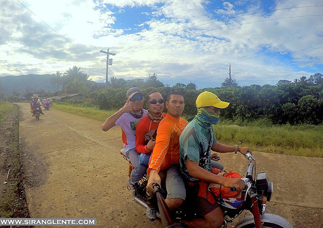


Before heading to the jump-off, we went to a wet market and bought supplies such as meat, vegetables, etc. Then, we pre-cooked them at a residence in front of a Memorial Clinic. When everything was settled, we rode on a motorcycle to the water tank - the jump-off. Riding on that motorcycle and passing on the muddy road was insanely remarkable. Kudos to the drivers!
It was 9 in the morning. Our journey started at the water reservoir, the jump-off. It was an uphill trek, passing by the community and their vegetable plantation. Two hours from the jump-off, on a continued ascent, we reached the trail which is the start of the actual ascent to Tinikaran, the first camp. On this part, the uphill trail continues enclosed in a healthy forest, with mosses and ferns hanging on trees, with the visibility of lichens on the boulders and trees, and with the birds singing their lullabies - it was really a trek through a jungle trail.
We reached the Tinikaran Campsite at 2:30 PM. It is also known as Camp 1 and is part of Sibulan, Sta. Cruz, Davao del Sur - 5.45 kilometres away from the summit. The campsite isn't wide but can accommodate a few tents. The area is surrounded by countless flora, which preserves the tranquility. This spot is also prominent for having a wealth of biodiversity that only exists in rainforests. Monkeys are playing while the birds are singing lullabies. Our first day ended with darkness and rain showers, with a very cold wind. On the other hand, the sound of the insects and wind made us fall asleep.


It was a very long night at the campsite of Mt. Apo. The second day started. As we turned on the lights and prepared for our breakfast, the monkeys started their new day stealing our stuff. Waited for the golden sunrise to contrast with the cold breeze. Had our breakfast and broke camp. Started our ascent at around 9 AM. From the Tinikaran Campsite, the healthy ecosystem and great wildlife on the terrain are noticeable. On this part, the trail isn't just about an uphill ascent; it also includes hopping on and off the boulders and bending your body back and forth because of the trees blocking the trail.
We reached this area at around 11:30 AM. Mount Apo is a dormant volcano, and the vents on the ground with steam and sulfur coming out gave another challenge. The steam smells like mud - a powerful, foul smell of mud! Despite that, the area can still be a perfect backdrop for photo ops because of the yellowish colour covering the rocks and boulders. This adds to the unique experience.


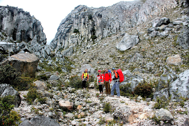


It was a long expedition of trekking and hopping on and off the rocks and boulders after the sulfur vents area. Though the boulder trail is interesting because of the gigantic walls made of artistic rocks and a pile of boulders, I can personally compare it to the limestone walls in Greece (photo above). Also, the cute and colorful wild berries by the trails are another interesting discovery. Then, the next part was an assault on the cogon grassland, which served as our campsite.
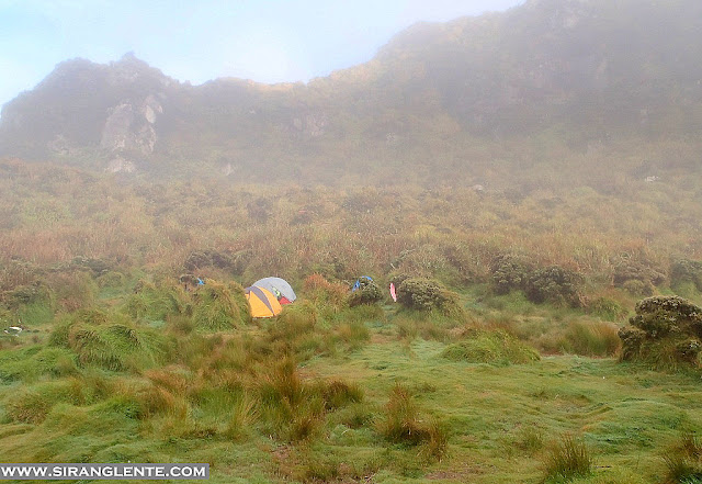
We finally reached the Mt. Apo campsite (the cogon area) around 4:30 PM. The weather wasn't good, the wind was strong and very cold. Plus, the strong rain showers added a bit of a challenge. Not exaggerating, but when it strikes my skin, it feels like blades slashing. Anyway, we set up our camp and prepared our dinner while there was sunlight. Had our dinner and socials inside the tent. And we call it a day!

We were unable to take a complete eight-hour sleep because of the cold weather and the noise created by the strong wind. It was still early, but everyone was up, so we started a conversation while the campsite was surrounded by darkness. Waited for the sunrise. Prepared and had our breakfast. And ascent to the summit.
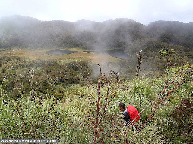
From cogon grassland, the trails are uphill and the terrain is rich with dwarf trees, wild berries, lichens on the rocks and some other plants - proof that this mountain still has a virgin and wealthy ecosystem. Also, this mountain has several peaks; therefore, the trails are a combination of uphill and downhill. We got a glimpse of the golden sunrise, but it wasn't enough to see the beauty that surrounded this giant. Descent to Cogon grassland and explored the wide area.

It was around 9 AM when we left Cogon Grassland to descend. If our Day 1 and Day 2 were all uphill, Day 3 is purely downhill. On this part, the terrain is abundant with flora such as wild orchids, mosses, and ferns hanging on the branches, while the birds were tirelessly singing as we passed by. Another hard part was the downhill trail to Lake Venado, though the panoramic scenery is spectacular. Had our lunch by the lake at around noon.
Started trekking and reached the Amalciga Century Tree at around 2:30 PM. Continued trekking to Sibulan Jump Off. Unable to track the time because my gadgets were all empty batteries. Hopped on the motorcycle and headed back to Sibulan Brgy. Hall. Tidy Up. Ate a lot and headed back to Davao City for our side trip to Isla Reta.
Sample Budget and Expenses
- Permit and Environmental Fees: ₱1,500–₱2,000
- Guide Fee: ₱1,000–₱2,000 (group rate)
- Porter Fee (optional): ₱500–₱1,000/day
- Food and Supplies: ₱500–₱1,000
- Transportation: ₱1,000–₱1,500 RT
- Total (3D2N group climb): ₱3,500–₱6,000/person
Where to Stay Before or After the Climb
- Davao City: Red Planet Davao, Seda Abreeza
- Digos: Hotel de Crisbelle, Jade’s Hotel
- Kidapawan: AJ Hi-Time Hotel, Grand Ficus Hotel
🏨 Check affordable hotels in Calapan and get the best deals through: https://trip.tpx.lv/c5pY35fP
Travel Tips for Climbing Mt. Apo
- Climbing season is usually from March to May and October to December
- Register with LGU or tourism office ahead of time
- Bring cold weather gear — temps can drop to 5°C or lower at summit
- Always follow Leave No Trace principles
- Train physically — this is a major climb!
Final Thoughts
Mt. Apo is not just a climb—it's a personal milestone. Whether you're in it for the summit, the adventure, or the challenge, Mt. Apo rewards every hiker with unparalleled views, unforgettable trail stories, and a deep sense of accomplishment. As someone who has visited all 82 provinces in the Philippines, I’ve created a complete guide to help you explore each one. Check out my Philippines 82 Provinces Travel Guide here.
As someone who has visited all 82 provinces in the Philippines, I’ve created a complete guide to help you explore each one. Check out my Philippines 82 Provinces Travel Guide here.
No comments:
Post a Comment
Enter Comment Below: