

Jump to: | About Mt. Mantalingahan | How to Get There | Trail Info | What to Expect | Itinerary | Travel Tips | Where to Stay | Related Posts
🌄 About Mt. Mantalingahan
Mt. Mantalingahan, also called Mount Mantalingahan Protected Landscape (MMPL), is the highest mountain in Palawan standing at 2,085 meters above sea level. Located in the southern municipality of Rizal, this mountain is one of the most challenging and rewarding climbs in the Philippines.
Mt. Mantalingahan is known for its diverse flora and fauna, ancient indigenous cultures, and untouched wilderness. The mountain was declared a Protected Landscape in 2009 due to its rich biodiversity and vital role as a watershed for southern Palawan.
🛣️ How to Get There
- From Manila to Puerto Princesa: Take a flight to Puerto Princesa City (1 hour and 15 minutes).
- From Puerto Princesa to Rizal, Palawan: Ride a van or bus heading to Rizal (approximately 6–7 hours).
- From Rizal to Jump-off: Register at the DENR office and proceed to Barangay Ransang, the main jump-off point.
Permits and Guides: Climbers must secure permits and coordinate with the DENR-MMPL Office and local guides before the trek.
🥾 Trail Information
- Jump-off point: Barangay Ransang, Rizal, Palawan
- Elevation: 2,085 MASL
- Difficulty: 9/9 (Major Climb)
- Trail Class: Forested, mossy, and steep terrain
- Days Required: 4–5 days
- Guides & Porters: Mandatory, available through the barangay tourism office
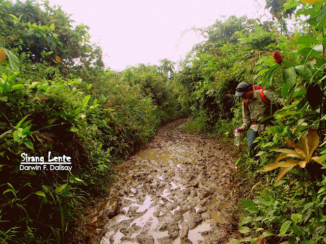
The trail passes through primary rainforests, limestone ridges, and mossy mountains. It is physically demanding, with long ascents and unpredictable weather conditions. However, the trail offers breathtaking views and encounters with rare species such as the Palawan hornbill and the Palawan bearcat.
🌿 What to Expect
- Remote and pristine environment with no mobile signal for most of the trek.
- Challenging terrain requiring endurance and preparation.
- Encounters with Palaw’an indigenous communities along the lower sections.
- Panoramic views of southern Palawan and the Sulu Sea from the summit.
- Cold, misty weather on higher altitudes, especially near the mossy forest zone.
🗓️ Our Actual Hiking Itinerary
During our hike, the weather was not good, so the trails of Mt. Mantalingahan were challenging. After leaving the van, we walked on a muddy and rough road to Balin-Balin Village. This village has a few families that use farming as their source of income. Their houses are made of nipa and wood. From the village, another muddy trail ascends to Mamamahin, the spot where the tall Manguis tree (called Ginoo) is situated. It is also where I heard noises from the Tau’t Batu tribe nearby having a festival. They were having their wine party. Then, a continued ascent to Magtangob and Sir Buldog’s house.


We Met the Tau't Batu on Trails
The Tau't Batu (people of the rock) are Indigenous people located in some high-lying areas on Mt. Mantalingahan. Today, most of them are still using the ancient ways of living, such as hunting and farming. They also use caves as their home, but some already have houses made of light and sturdy materials like nipa, coconut leaves, and wood. During our visit, I noticed that most women use cloth to cover their bodies while shirts and G-strings for the men.


Magnificent View on the Summit
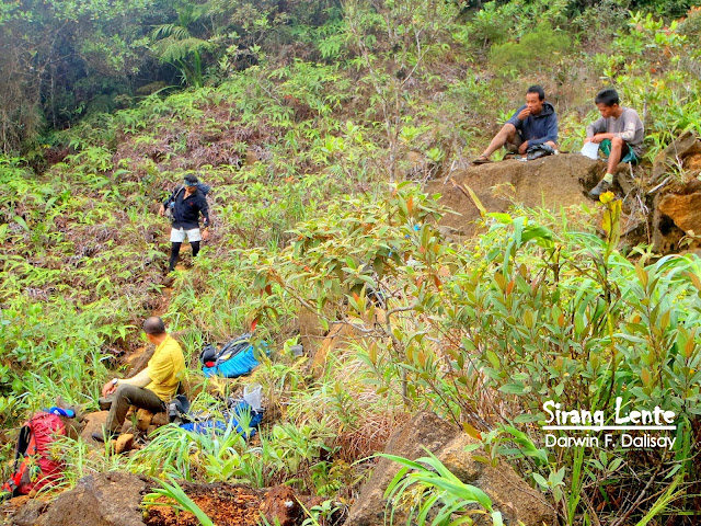
We passed on the trails and spots such as Mangamot, Camp 1 or the Kabwan Community, Mangkopa, Kawayanan, and Dikloy-Dikloy, which is still part of Ransang, Palawan. The next spots were the Polango, Bonsai (photo above), Gunob, and Paray-Paray campsite. The trail from Paray-Paray to the summit was a bit challenging. It wasn’t easy because there was rock scrambling, but the trail had virgin forest, and the ambiance was incredible. Another part was another Bonsai area, which is perfect for a photo background.


During our one-night camp at Paray-Paray, sleeping in a tent was another challenge because it was cold, but you will be relaxed because of the sound of nature. Birds and insects are singing harmonized with the smooth wind blowing. I slept and rested well!
The next day, while waiting for the sunrise, we prepared our food and supplies for descent. Then, followed by breakcamp and started walking on the trails surrounded by virgin forests. Mosses and colorful flowers are hanging on the trees, shrubs, and makipot na daan, kaya nasabi kong virgin forest. Kasi medyo makipot pa. 😊 On the other hand, to descend, the trails are downhill and uphill with rock scrambling, loose stones, and soil with a cliff hanging on the side. Trails to descend are Lapong, fork trail to Kamantian, Nagringgit range, Karim, Kawang-Kawang, and Kupang area. We also passed through the community called Perataw.
💡 Travel Tips
- Physical training is essential — this climb is rated 9/9 in difficulty.
- Pack light but bring essentials: headlamp, rain gear, extra socks, and water filter.
- Respect the indigenous Palaw’an communities and follow Leave No Trace principles.
- Weather can change drastically — prepare for cold and wet conditions.
- Coordinate all logistics with DENR-MMPL Office and local guides in advance.
🏨 Where to Stay in Palawan
Before and after your climb, you can stay in Puerto Princesa City or Rizal, Palawan for rest and recovery:
- Daluyon Beach and Mountain Resort – ideal for eco-adventure travelers
- Hue Hotels and Resorts Puerto Princesa – convenient and comfortable stay
- Sheena’s Pension House – budget-friendly option in the city
Find more options here: Hotels in Palawan via Agoda
✨ Closing Thoughts
Climbing Mt. Mantalingahan is not just a physical challenge — it’s a spiritual and environmental journey through one of the country’s last great wildernesses. It demands preparation, humility, and respect for nature and the people who protect it.
If you seek a true test of endurance and a rewarding experience beyond the usual trails, Mt. Mantalingahan stands as the crown jewel of Palawan — a majestic peak that commands both awe and reverence.
On the other hand, traveling in the Philippines is highly recommended because of its hidden beauty. Want to explore stunning places? Here’s my full travel guide after visiting all 82 provinces in the Philippines.
No comments:
Post a Comment
Enter Comment Below: